|
 s we watch the strongest hurricane
ever seen by scientists in the eastern Pacific dissipate, we should pause
and reflect on the flood history of San Diego. It hasn't happened recently
or often, but floods do occur and some are big. This information may be
surprising for the homeowners and businessmen who have recently moved to
the city and live and work in the flood plains. If flood damage does occur,
who pays? The taxpayers of San Diego and the nation not the people who made
it happen. s we watch the strongest hurricane
ever seen by scientists in the eastern Pacific dissipate, we should pause
and reflect on the flood history of San Diego. It hasn't happened recently
or often, but floods do occur and some are big. This information may be
surprising for the homeowners and businessmen who have recently moved to
the city and live and work in the flood plains. If flood damage does occur,
who pays? The taxpayers of San Diego and the nation not the people who made
it happen.
 As we look at our creeks and waterways
we see exotic weeds clogging the channels, replacing attractive trees such
as sycamore and willow. We see rusty abandoned shopping carts and trash
to highlight their lack of care. Yet the small streams and rivers that flow
through San Diego are critical for storm water drainage. If we repaired
and restored them, we could enhance the quality of urban life, save money,
reduce the cost of public health problems, reduce flood risk and damage,
and maximize the economic and ecological benefits of the services they provide.
If they remain ignored and unloved, we can expect extremely costly damage
will occur. As we look at our creeks and waterways
we see exotic weeds clogging the channels, replacing attractive trees such
as sycamore and willow. We see rusty abandoned shopping carts and trash
to highlight their lack of care. Yet the small streams and rivers that flow
through San Diego are critical for storm water drainage. If we repaired
and restored them, we could enhance the quality of urban life, save money,
reduce the cost of public health problems, reduce flood risk and damage,
and maximize the economic and ecological benefits of the services they provide.
If they remain ignored and unloved, we can expect extremely costly damage
will occur.
|
| |
The San Diego River watershed
covers a large area. In the past, when it was less urbanized than today,
the San Diego River experienced several very large floods and many minor
ones. Mission Valley was often full, bank to bank, and cut off all travel
for several days at a time. The heavy rains of 1862 inundated most of California
and filled much of the Central Valley. The heavy rains and overgrazed hills
led to massive floods that flushed out the creeks and rivers of Southern
California. The Santa Ana River peaked at 317,000 cfs (cubic feet per second;
a cubic foot is about 8 gallons). This is more than 7 times the volume of
the recent flood generated on the Colorado River to scour the river and
create new sand bars.
The San Diego River only reached
a third this size, but at 94,500 cfs (which would completely fill Qualcomm
stadium every couple of minutes) it was an awesome flood. The smaller flood
of 1916 was also impressive and did considerable damage. Even the 1927 flood
was significant, and it is worth noting that the last long dry spell like
the current one occurred in 1927. |
| |
Partly in response to the flooding,
and in a futile effort to meet local drinking water needs with local resources,
dams have now been built on several of the streams that feed the river and
on the river itself. This provides an increase in flood protection, but
in 1980 San Diego's reservoirs were all full and spillways were running
as a major storm approached. Fortunately, at the last minute it swung through
Baja instead of San Diego. If it had hit San Diego, the damage would have
been in the billions of dollars.
Sadly, many of the benefits of these
dams are offset by the effects of urbanization. As we build houses, offices,
roads and parking lots, we increase the land area that is impervious to
water. As a result, the rain has no way of entering the soil. Soil compacted
by equipment and revegetated with weeds also retains much less water than
undisturbed ecosystems. Rather than being held and moved into the ground,
a high proportion of the rain quickly runs off into streams, causing more
frequent and greater flooding than existed in the natural watershed.
Research has shown clearly that floods
may become six times larger; high water levels that previously occurred
only once every 100 years (on average) in an unurbanized setting may now
recur every 10 to 20 years. A rainfall greater than the 100-year event can
have catastrophic effects.
Mission Valley Floods
|
| |
Flood Volume, peak CFS
|
|
|
Season
|
Santee
|
Mission Valley
|
Urban Impact
|
Damage Estimate
|
| 1862 |
94,500 |
80,000 |
|
|
| 1978 |
3,010 |
15,000 |
400% |
|
| 1979 |
2,690 |
17,000 |
500% |
|
| 1980 |
3,420 |
27,000 |
700% |
$120 million |
The effects of urbanization can be
readily observed in Mission Valley a flood disaster waiting to happen. The
City of San Diego should take aggressive steps to limit its liability for
the inevitable flooding that will occur.
Imagine what will happen when we
have a big rain storm, like many in the past. The flows at Santee in 1862
were almost 30 times higher than in the very expensive flood of 1980. While
upstream dams will capture some of the water, increases from urban runoff
may offset these benefits, and flood damage in Mission Valley will be very
extensive and costly. Estimated peak flow in Mission Valley (including the
protective effects of El Capitan and San Vincente Reservoirs) is 80,000
cfs.
Yet the channel capacity is far less
than that. Why? To put it simply, rain is rain and floods are floods, but
politics is politics. Pressure for development has repeatedly overwhelmed
common sense and prudence. Many well-intentioned people have failed to look
at the historical record and the results of research on the effects of urbanization
on flooding. Ignorance is bliss only until it rains.
Notable Mission Valley Floods
|
Year
|
Peak Volume, cfs at Santee
|
1862 |
94500 |
1867 |
30,000 |
1874 |
33,000 |
1884 |
60,000 |
1889 |
34,000 |
1891 |
33,500 |
1895 |
45,000 |
1916 |
70,000 |
1927 |
45,400 |
1980 |
3,420 |
The history of flood control capacity
shows what happened. The floodwater planners of the Corps of Engineers were
under no political pressure in 1950. They could calculate a realistic storm
flow and plan according, estimating Mission Valley peak flows of 115,000
cfs. They might choose an inappropriate solution (concrete and more concrete),
but at least they were conservative. As Mission Valley land became increasingly
attractive for development and memories of the floods of 1938, 1937 and
1927 faded, so did consideration of flood flows.
In 1959, when the Town and Country
Hotel was built, channel capacity was reduced to only a few thousand cfs.
It soon became clear that this wouldn't be enough. By 1971, the city was
requiring channel capacity for a 50-year flood with a calculated volume
of 36,000 cfs. Subsequently, the capacity has been increased to 49,000 cfs.
But this remains little more than half the potential flood flow for a 100-year
storm. And, there are 1,000 year storms out there waiting to happen. |
 |
Clearly, the City and County of San
Diego and other local cities should have developed watershed and water way
planning many years ago. The goal of these efforts should be to protect
the public treasury and taxpayers from preventable costs and to promote
the public health, safety and welfare. Waterways in their natural form are
irreplaceable community assets with considerable value to present and future
generations. They provide critical ecosystem services with very high dollar
values that have been historically neglected. They also provide ecological,
recreational, educational and aesthetic benefits. Taxpayers should refuse
to pay for stupid behavior.
The objectives of this effort should
be to:
- Minimize costs to the public and to private land and
property owners.
- Protect and enhance hydrologic function and minimize
flooding and erosion.
- Protect and enhance water quality (in stream and near
ocean outfalls).
- Enhance the economic value of areas adjacent to creeks.
- Protect adjacent development from stream bank failure
and limit adjacent development that would impact stream banks.
- Protect and enhance private property rights.
- Protect and enhance waterways as recreational areas for
people, and as habitat and corridors for fish, birds, mammals and other
wildlife.
- Enhance the urban environment with natural and open space
features.
- Provide educational opportunities.
- Protect cultural and archaeological resources.
- Maintain and enhance aesthetic qualities.
- Provide trail corridors and other recreational opportunities
along some waterways.
Watershed planning should be done
throughout the area. The first and most important step in planning should
be a careful determination of the economic benefits of improved management
policies. This could be done by calculating the costs of past flood events
(what was lost, who lost, who paid) and estimating the potential costs of
a future large flood. Historically, development has been heavily subsidized
by public taxpayers, who foot much of the bill for providing services and
infrastructure for development and then pay the costs of the impact generated
by these activities.
By the same token, developers should
not be used as a deep-pocket payer for city activities that are unrelated
to development. Users should pay for their activities.
Storm water control technology should
be installed as a normal part of all development activities. To protect
Chesapeake Bay, the state of Maryland requires no net change in storm water
runoff after development. We should do no less. Like Maryland, we should
have a storm water park, showing homeowners, developers and engineers how
these infiltration beds and retention systems work. Retaining the water
on site would also reduce irrigation costs and improve base flows in these
much degraded streams and rivers. We should also enact much more stringent
erosion control policies and recover costs for sediment that clogs drains,
gutters and creeks when erosion control is neglected.
Let the San Diego City Council and
County Board of Supervisors know that you are sick of paying for other peoples'
mistakes! Demand storm water planning and improved erosion control now.
Ask for a watershed program to protect our pocketbooks, our health and our
environment. |
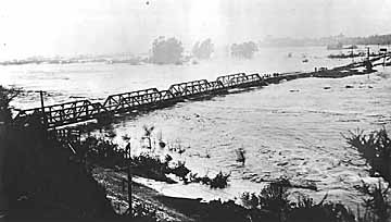 Photo taken on February 2,
1927 shows the Old Town railroad bridge washed out by the flood. This rail
right-of-way still exists - you can see it looking east from I-5; Friars
Rd. runs underneath it. Needless to say, if a similar flood happened today,
you just might see the top of a large semi truck stuck on Friars. Photo:
San Diego Historical Society, photo collection.
Photo taken on February 2,
1927 shows the Old Town railroad bridge washed out by the flood. This rail
right-of-way still exists - you can see it looking east from I-5; Friars
Rd. runs underneath it. Needless to say, if a similar flood happened today,
you just might see the top of a large semi truck stuck on Friars. Photo:
San Diego Historical Society, photo collection.